
By now, many of us are familiar with news regarding the imposing Cascadia earthquake that is projected to strike the Pacific Northwest in the next 100-500 years. The New Yorker is one of the best articles written on this subject, and we wanted to provide you with just the cold hard facts from this article to save you time (the official article is over 15 pages long). The original article can be found at:
http://www.newyorker.com/magazine/2015/07/20/the-really-big-one
For reference, a 30 second earthquake has a magnitude of 7.4-7.6. A minute-long earthquake has a magnitude of 7.8-7.9. A two minute-long earthquake has a magnitude of 8.2-8.6; a four minute-long earthquake has a magnitude of ~8.8.
The recent earthquake in Japan serves as a good reference to the Pacific northwest, demonstrating the moving continental plates and seismology levels in the Pacific Ocean. The Japanese earthquake was at a 9.0 magnitude, going longer than 4 minutes; this is expected to be the same for the Pacific Northwest. The Japanese earthquake killed more than 18,000 people, and cost an estimated $220 billion.
The scariest aspect of an earthquake in the Northwest is not the shaking itself, but the tsunami that rolls in. The water is supposed to come crashing in from the Puget sound, flowing all the way east to I-5 approximately 15 minutes after the earthquake begins. The boundary of this earthquake is not defined by the well-known San Andreas line, but instead by the Cascadia subduction zone, which runs for 700 miles off the coast of the Pacific NW, starting in Northern California and continuing through Vancouver, BC. The Cascadia Zone got its name from the Cascade Mountain range in the NW.
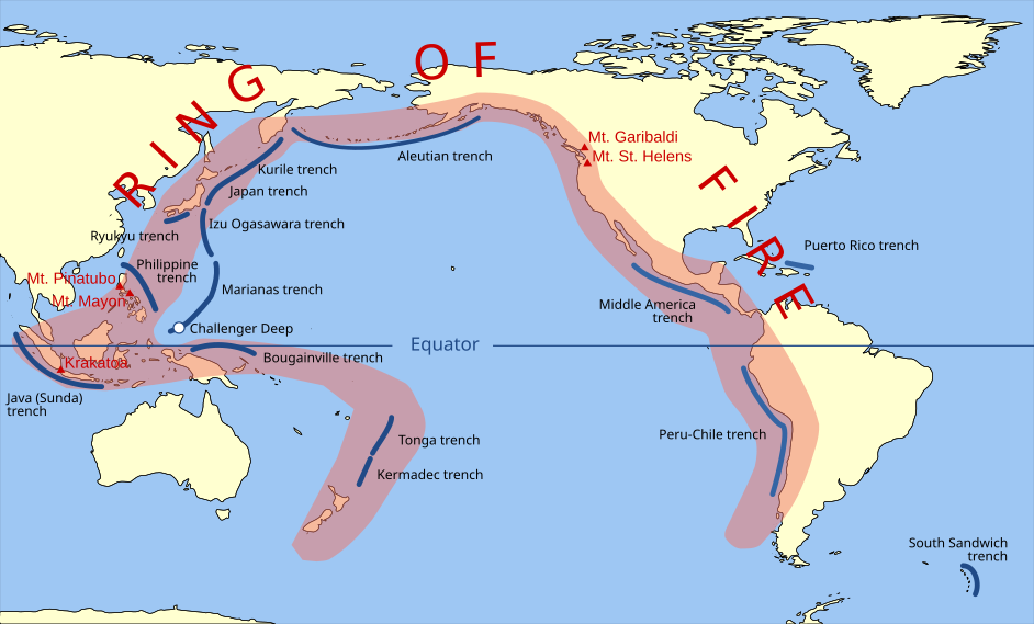
In Washington, we are living on the North American tectonic plate. Adjacent to Washington (on the west) lies the Juan De Fuca plate, which embodies the pacific ocean. About 500 miles west of the Juan De Fuca Plate is the Pacific plate; this connection represents part of the “ring of fire”, which composes roughly 542 volcanoes in the Pacific ocean shaped like a ring of fire. Currently, the Juan De Fuca plate is slipping under the North American plate (this movement is characterized as the Cascadia Subduction Zone). Eventually, the Juan De Fuca plate can only slide so far under until it hits the unbudgeable mass at the center of the North American plate, this bumping and breaking of rocks (when both plates hit) will cause “the big one”, that is suspected to happen in the Pacific Northwest anytime in the next 500 years. This quake is suspected to be between magnitudes of 8.0 – 9.2, depending on quickly and how much the Cascadia Subduction Zone gives way to the Juan De Fuca Plate slipping under– the more and faster the Plate slips under, the greater the magnitude; the less and slower the Plate slips under, the smaller the magnitude. See pictures below for further reference:


Source: Wikipedia (I know, its Wikipedia, but it provides excellent visual explanation and understanding)
By seeing the closest picture above, we can see that the Cascadia Subduction Zone stretches from Northern California to Vancouver B.C. The worry is not necessarily the earthquake, but the tsunami that is supposed to follow 15 minutes after the earthquake strikes. This wave is supposed to be 700 miles long, and would easily take out coastal towns and cities that are west of I-5. The projected deaths of this earthquake is supposed to reach ~13,000, along with 27,000 people injured and 1 million displaced residents.
Supporting evidence for this impending earthquake comes from the ring of fire. With constant high magnitude earthquakes occurring in the ring (magnitudes usually of 9.0 and above), it serves as evidence for a high magnitude earthquake due near the Pacific NW.
/cdn0.vox-cdn.com/uploads/chorus_asset/file/3882240/Screen%20Shot%202015-07-16%20at%202.39.09%20PM.png)
Source: Oregon Department of Geology and Mineral Institutes
The ring of fire is truly a ring of subduction zones– with the colliding, sinking, slipping, compression, and tension of various oceanic plates going beneath continental plates, mountains form; this demonstrates and explains all the highly active volcanoes in this treacherous area.
Surprisingly, seismologists today have gathered much of their research and evidence from ancient Japanese and Native American records of historical earthquakes. Using trees (western red cedars in the “ghost forest”) as reference marks, as well as Native stories of earthquakes, seismologists concluded that the Pacific NW has experienced 41 subduction-zone earthquakes in the past 10,000 years! From these numbers, the recurrence interval of Cascadia earthquakes is 243 years (see timeline above). This time period is not ideal because it allows mankind to build an entire civilization, which will soon turn into rubble and/or get drowned.
Currently, we do not have the infrastructure to resist earthquakes and tsunamis, so the best way to prepare for this situation is to learn how to respond. A compressional wave will strike the Pacific NW, which will feel like a sudden jolt to humans. This wave occurs ~60 seconds before the actual shaking; this will allow earthquake warnings and sirens to sound throughout the region. In this time, it is ideal to remain in your home, underneath a doorway/beam or under a table. Here is a by the numbers summary of the earthquake impact:
- Unless protected, anything glass will shatter.
- The electrical grid will fail.
- Bookshelves, lamps, computers, cannisters will fall down.
- 75% of all structures in WA state are not designed to withstand a major earthquake; the larger structures in particular will likely collapse.
- 1 million buildings are projected to collapse. 3,000 of them schools.
- Half of all highway bridges in the Cascadia region/subduction zone will collapse.
- 2/3 of Cascadia railways and airports will collapse.
- 1/3 of all fire stations will collapse (in Cascadia subduction zone).
- 1/2 of all police stations will collapse (in Cascadia subduction zone)
- 2/3 of hospitals in Cascadia will collapse.
- 30,000 Seattle homes will experience land slide and/or liquefaction (where solid ground behaves like liquid).
- 15% of Seattle is built on liquefiable land.
- On this liquefiable land, there is 17 day-care centers, and 34,500 residential homes.
- Altogether, this shaking will trigger fires, flooding, pipe failures, dams, and hazardous-material spills.
And the disaster is not over yet. There is an even bigger danger approaching: the tsunami. About 15 minutes after the shaking, the tsunami is supposed to strike the coast. This is practically unsurvivable. The closest way to survival is to get to high ground as fast as possible. In other words, even if you think you are high enough on the downtown Seattle hill, keep running east to Capitol Hill, the flooding is supposed to stop just west of I-5; Capitol Hill is just east of I-5. Ultimately, depending on location, one will have between 10-30 minutes to get out (if west of I-5). Since the earthquake will cause impassable roads and mishap panic-alert accidents, leaving on foot or bike is the best option. One will not have time to grab belongings or searching for others; JUST GO. You run for your life. Here is some tsunami stats by the numbers:
- The average person is knocked over by ankle-deep water moving at 6.7 mi/hr. The tsunami will likely be moving at ~15 mi/hr when it hits.
- The tsunami height will vary depending on the coastal elevation. The wave height could max out at 100 ft.; if you live in an elevated area, the wave could still pass through at 20 ft. high.
- The tsunami wave will look like the whole ocean elevated, overtaking land.
- The tsunami will not be soft– it will be a 5-story deluge of waste, trucks, doorframes, concrete blocks, boats, utility poles, and other fatal material.
- The entire tsunami devastation will be so vast, that one must be in the international space station to see the disaster in its entirety.
- Just east of I-5 and in its corridor, it will take 1-3 months to restore electricity.
- It will take 1 month – 1 year to restore drinking water and sewer service.
- It will take 6 mo. – 1 yr. to restore major highways.
- It will take 18 months to restore health-care facilities.
- Those a little west of I-5 will spend:
- 3-6 months without electricity
- 1-3 years without drinking water/sewage system
- 3+ years without hospitals
- For those who remain in the tsunami inundation zone, estimates are inapplicable because the area will be uninhabitable for years
- The economy in the Pacific NW will collapse– much of the government owned infrastructure and systems will go to waste (all those tax dollars would go to waste!). Private and public businesses in their previous inundated location could not operate any longer. This results in an economic shutdown; many essential businesses that are crucial to the functioning, transportation, and defense of this country, will falter (e.g. Boeing, Starbucks, Amazon).
Casualties from the tsunami:
- Same numbers as earthquake (which included tsunami) — 27,000 injured, 13,000 dead.
- ^^ These stats are based on a winter Seattle day. If the earthquake struck in the summer, where residents flock to coastal beaches, the numbers would be much higher.
A large theme that comes to focus is the issue of health and safety. While current society is wrapped up in the latest technological innovation or current fad, we are not thinking ahead about the long-term defense, stabilization, and protection of our country for the future. Yes, we have a strong military. Yes, we have a prosperous and growing economy. But when a region is at risk for a natural disaster, shouldn’t we build from the inside-out? By having earthquake-resistant and stable infrastructure, as well as a carefully crafted water/sewage/industrial engineering system, the potential devastation could be significantly reduced. Our country must think deeply about the future and its natural threats.
We hope you gained a greater insight by reading this article. Remember, if you suspect a tsunami, run to the nearest and highest ground as quickly as possible for your own safety. Much of this article was summarized from the extensive and popular New Yorker:
http://www.newyorker.com/magazine/2015/07/20/the-really-big-one
If you have any questions or comments, please contact us at Magnolia Insurance Agency.
Sincerely,
Magnolia Insurance
magnoliainsurance@comcast.net | (206) 284-4886
3424 W. McGraw St.
Seattle, WA 98199
